Will river erosion below the Three Gorges Dam stop in the middle
The environmental impact of the Three Gorges Dam has been a subject of vigorous academic, political and social debate since its inception. This includes the key issue of post-dam river channel erosion, which was predicted by the feasibility study to extend to the river mouth. In this paper we examine the geomorphic response of the channel of the middle Yangtze for 660 km downstream of the dam. Using data on channel characteristics, bed material and sediment transport, we show that in the decade following the dam closure, pre-dam seasonal erosion has been replaced by year-round erosion, a pattern most marked at the upstream end of the study area. The sediment carrying capacity of the river channel has been largely reduced below the dam. The locus of bed scour has moved progressively downstream, ceasing as the bed material became too coarse to be transported (e.g. D50: 0.29 mm pre-dam coarsened to 20 mm below the dam by 2008). About 400 km below the dam there is a reduction in channel slope that changes the sediment carrying capacity from 0.25 kg m-3 to only about 0.05 kg m-3, which is insufficient to move bed sediment. The new long-term hydro-morphological equilibrium that will be established in this section of the middle Yangtze will prevent the further incision downstream initiated by the Three Gorges Dam. The results suggest that the full extent of adverse environmental impact predicted by the pre-dam studies will not eventuate.
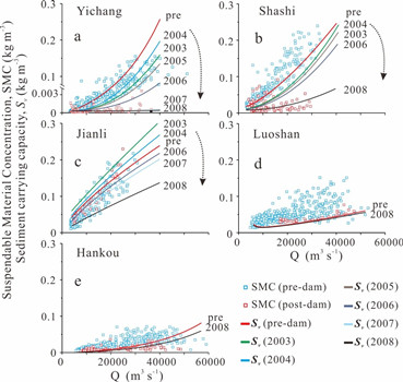
Fig. 4. Suspendable material concentration (SMC) and sediment carrying capacity (Sv) pre and post the Three Gorges Dam for five stations sequentially downstream.
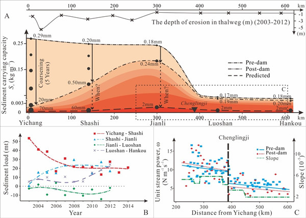
Fig. 5. A) Schematic diagram showing downstream changes in sediment-carrying capacity at a discharge of 40,000 m3 s-1 in the middle Yangtze River pre- and post-dam, and the predicted value based on expected coarsening of riverbed sediment. Measured incision amount from 2003 to 2013 is plotted above (CWRC, 2000–2014); B) Annual sediment loads generated in the four reaches of this section of the river from 2003 to 2012/14 (CWRC, 2000–2014). Curve fitting by polynomial; C) Downstream trends of unit stream power from Jianli (S3) to Luoshan (S4) pre- and post-dam and river channel slope through this reach (Data sourced from Wang et al. (2009)).
List of relate publications:
-
Journal of Hydrology ,
2017 ,
554
: 24-31