Detecting wetland changes in Shanghai, China using FORMOSAT and Landsat TM imagery
Understanding the state of wetland ecosystems and their changes at the national and local levels is critical for wetland conservation, management, decision-making, and policy development practices. This study analyzed the wetlands in Shanghai, a province-level city, using remote sensing, image processing, and geographic information systems (GIS) techniques based on the Chinese national wetland inventory procedure and standards. FORMOSAT imagery acquired in 2012 and Navy nautical charts of the Yangtze estuarine area were used in conjunction with object-oriented segmentation, expert interpretation, and field validation to determine wetland status. Landsat imagery from 1985, 1995, 2000, 2003 and 2013 as well as social-economic data collected from 1985 to 2013 were used to further assess wetland changes. In 2013, Shanghai contained 376970.6 ha of wetlands, and 78.8% of all wetlands were in marine or estuarine systems. Estuarine waters comprised the single largest wetland category. Between the first national wetland inventory in 2003 and the second national wetland inventory in 2013, Shanghai lost 50519.1 ha of wetlands, amounting to a mean annual loss rate of 1.2% or an 11.8% loss over the decade. Declines were proportionately higher in marine and estuarine wetlands, with an annual loss of 1.8%, while there was a sharp increase of 1882.6% in constructed water storage areas for human uses. Diking, filling, impoundment and reclamation, which are all attributable to the economic development and urbanization associated with population increases, were the major factors that explained the gain and loss of wetlands. Additional factors affecting wetland losses and gains include sediment trapping by the hydropower system, which reduces supply to the estuary and erodes wetlands, and sediment trapping by the jetties, spur dikes, and diversion bulwark associated with a navigation channel deepening project, which has the converse effect, increasing saltmarsh wetland area at Jiuduansha shoal by three times between 2000 and 2013.
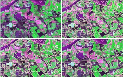
Fig. 2. (a) FORMOSAT-2 data from Dalian Lake, Shanghai obtained in September 2012 (RGB = bands 1, 4, and 2). (b) Image segmentation based on spectral and spatial criteria with a segmentation scale of 20, a shape of 0.3 and a compactness of 0.7. (c) Pre-classification of wetlands from non-wetlands using NDVI and MNDWI thresholds. (d) Delineation of dissolved patches of wetlands, where the type was identified by visual interpretation and then verified in the field.
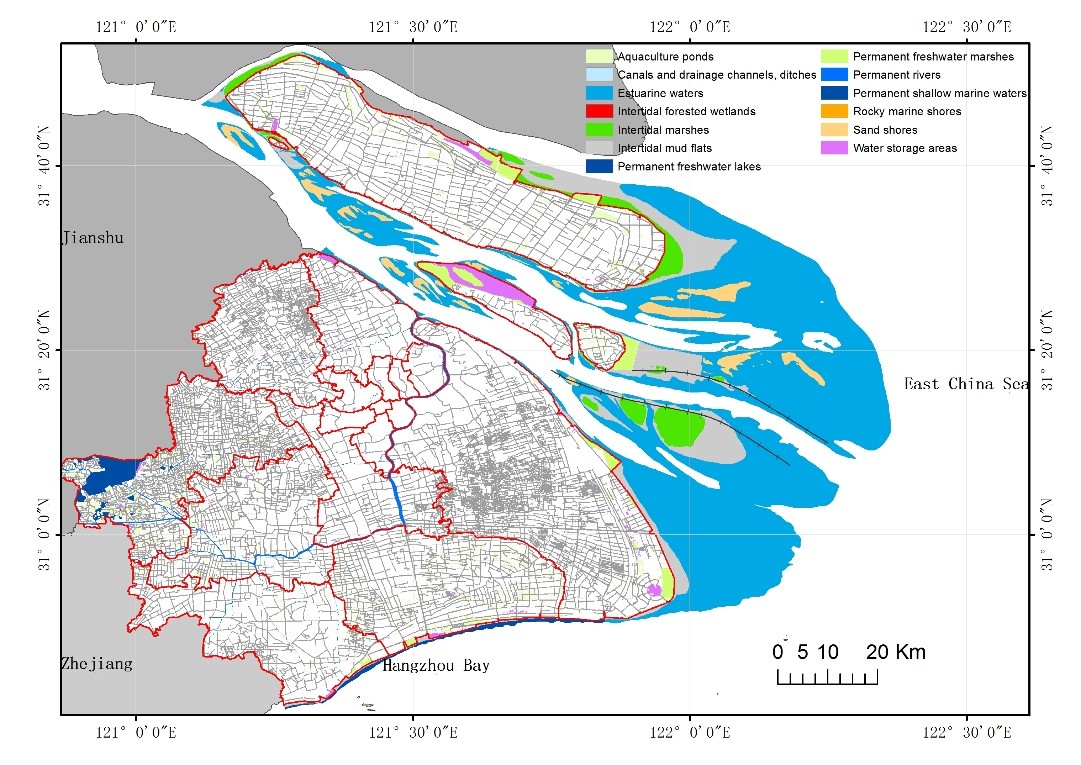
Fig. 4. Type and spatial distribution of wetland habitats in Shanghai in 2013. There were five categories and thirteen types of wetlands (excluding paddy fields) in Shanghai. Estuarine and coastal wetland were the major category, including estuarine waters, intertidal forested wetlands, intertidal marshes, intertidal mud flat, rocky marine shores, sand shores and permanent shallow marine waters.
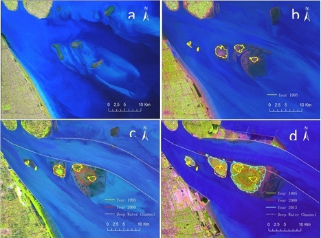
Fig. 8. The accretion of saltmarsh wetland in the Jiuduansha shoal, Shanghai from 1985 to 2013. (a) 1985. (b) 1995. (c) 2000. (d) 2013. The different color lines represent the boundaries of the saltmarshes in those years; the rate of accretion of saltmarsh wetlands is slow, as sediment deposits have decreased since the construction of the Three Gorges Dam. (For interpretation of the references to colour in this figure legend, the reader is referred to the web version of this article.)
List of relate publications:
-
Journal of Hydrology ,
2015 ,
529
: 1-10